Baltimore Red Line
Public transportation and I are best buds. Unfortunately the public transportation network of Baltimore is limited to the north-south centric Light Rail, North by North-West Metro and unnavigable and frustratingly slow buses. What is missing is the ability to go east-west through the city on a single mode of transportation in a timely manor. The Baltimore Red Line is the Maryland Transportation Authorities solution to this predicament.
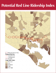
As a final project of Human-Environmental Geography I struck out to determine whether the designated route through Baltimore would hit the centers of population with the highest concentration of potential light rail riders.
To determine who will use this new mode of transportation I first investigated the demographics of current light rail users. These tended to be white collar, have access to an automobile, are in their mid-twenties and have a higher than average income.
With this demographic information, I generated an index to determine which Transportation Analysis Zone had the highest population of potential red line riders. This data leads me to believe that although the red line is valuable in its current location, it would be more beneficial if it extended through Baltimore into Eastern Baltimore County.